Summary
This project aimed to foster multisectoral collaboration toward a dynamic, web-based age-friendly mapping tool for Bergen County and Somerset County. The state-level view of the map is available at https://agefriendlymapping.rutgers.edu.
This tool serves to identify the spatial locations of high concentrations of older residents with unique demographic characteristics, alongside the spatial locations of organizations and other community assets that are important for residents who are aging in place. The team is using a case study approach to describe how the tool developed, key decisions points, and essential resources; ways in which the participating organizations collaborated; and how the mapping project enhances age-friendly actions within county government systems and beyond.
Researchers and Partners
- Emily Greenfield, PhD, principal investigator, associate professor, Rutgers School of Social Work
- Karen Alexander, MPA, principal investigator, senior research project manager and managing director of the New Jersey Travel Independence Program, Rutgers Bloustein School
Participating organizations:
-
Rutgers School of Social Work
-
Rutgers Edward J. Bloustein School of Planning and Public Policy
-
Rutgers New Jersey Agricultural Experiment Station Office of Research Analytics
-
Somerset County Office on Aging and Disability Services
-
Somerset County Planning Division
-
Bergen County Administration
-
Bergen County Division of Senior Services
About this Project
Initial Approach
How did this project idea originate?
The project idea originated when Dr. Greenfield learned about a dynamic mapping tool developed for Age-Friendly New York City. She was impressed by how the map allowed for visually depicting the geographic locations of community-based assets across the five boroughs, alongside spatial concentrations of older adults who are most likely to be in need of specialized resources (e.g., because of limited incomes or speaking a language other than English). She understood the potential of adapting the map for age-friendly planning and policy in New Jersey. The CDHW-IRG provided the opportunity to pursue the idea in partnership with collaborators both within and outside of the University.
How did the partnerships come together?
This project leverages collaborative relationships among Rutgers faculty and staff alongside leaders in the public and private sectors. These relationships were cultivated well before this project, including those between the Bloustein School and Somerset County; Social Work and Bergen County; and Rutgers with AARP-NJ and the New York Academy of Medicine.
The mapping project has deepened these relationships, as well as created new connections that broaden a larger ecosystem of organizations involved in age-friendly community work in New Jersey.
 What is the primary issue or concern the community is facing that you are investigating in your research?
Older adults are among the fastest growing population groups in New Jersey and worldwide. There is tremendous variation in people’s opportunities for health, well-being, safety, and inclusion in later life based both on their social positions (e.g., in the context of structural racism) and geo-spatial positions. This mapping project provides a tool for visualizing both categories of context for aging, while simultaneously encouraging multisectoral collaboration to better address aging-related challenges and opportunities at the regional and municipal levels.
How did this inform research design?
The primary goal of this project was to produce a dynamic, web-based mapping tool to identify the spatial locations of high concentrations of older adults with shared characteristics (e.g., by health status, income, very old age) alongside the spatial locations of assets in the local community (e.g., adult day centers, multi-service social service organizations). The map draws on an open-source platform created by the New York Academy of Medicine as part of Age-Friendly NYC. The project has deliberately engaged diverse stakeholders in the process of designing the map, which has encouraged greater inter-departmental collaboration within County government on population aging and also has deepened university-community partnerships on aging and Geographic Information Systems (GIS) methods.
What is the significance of this project, how is it unique?
One of the most significant outcomes of this project is the launch of the Age-Friendly Somerset County (AFSC) initiative. This initiative is the first of its kind to be formalized through membership in the AARP Network of Age-Friendly States and Communities at the county level in New Jersey. AFSC aims to promote long lives by developing age-friendly planning, policies, and services through public-private partnerships and greater inter-departmental collaboration. Since the start of the CDHW project, Rutgers has convened meetings with Somerset County leaders and AARP-NJ on a monthly basis. These meetings led, in part, to the development of the AFSC.
Evolution and Change
What is the primary research method?
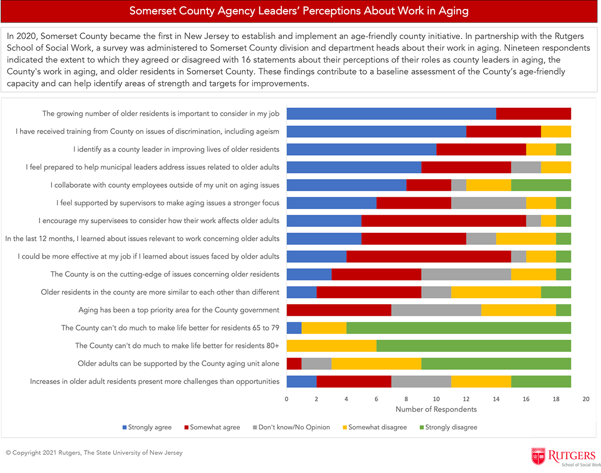
Our methods are descriptive. We are documenting the multi-organizational group processes to better inform other Counties in New Jersey that similarly aim to develop an age-friendly mapping tool for their geographies. The process of creating the map itself involves administrative records and GIS technology. In addition, we collected responses to a brief online survey of Somerset County Division and Department Heads in the fall of 2020 regarding the perceptions of their own and the County’s work on aging. Survey findings contribute to a baseline assessment for the County’s broader age-friendly initiative.
 How have you engaged community partners in this method?
Community partners are true partners. We have approached this work not as a research study, but instead, as a collaborative project that has the potential to benefit all organizations involved. All decisions concerning the map have been made in partnership. Even though Rutgers is largely providing the technical resources to produce the map, the data regarding community resources feeding into the maps are organized by the Counties, and all files underlying the maps will be transferred to the Counties at the end of the project for long-term use and development.
Are there unique challenges to this study?
This project is one of many for each of the organizational entities involved in it. In the context of many other demands on the leaders’ time, and their work flow timelines being different from each other, developing the mapping tool has taken place slowly, but steadily. COVID-19 also slowed down our progress because of the introduction of even more time-sensitive demands on professionals’ time. Nevertheless, we are on track to complete the project within the one-year extension period with both county government systems.
Results and Findings
What are your key findings so far?
As of February 2021, the Rutgers GIS team created a beta of the map for both counties. We are now working on adding layers of data from the U.S. Census Bureau. We also administered the survey of County Division and Department Heads in Somerset. Key findings are noted below. These data will serve as a baseline assessment for the County and also will serve as pilot data for future research endeavors by the Rutgers team.

Did the study change or evolve based on your work with community partners?
The focus of our work with Bergen County has remained on creating the map. With Somerset County, our work has focused on the mapping project, as well as collaborative discussions and support for its larger age-friendly county initiative.
How will your findings impact or benefit the communities you are working in?
The findings may inform regional-based policy and practice efforts toward making communities more equitable for healthy aging. Using GIS technology, stakeholders can tailor place-specific strategies for improving older adults’ quality of life, health, and well-being across diverse socio-geographic settings and social positions.
Next Steps
Dissemination into other counties
We plan to begin disseminating findings to other counties in New Jersey as well as at national conferences. We hope to demonstrate the value of the mapping tool itself, as well as the ways in which creating the map enhances collaborations toward more equitable age-friendly planning and policies at the local level.
